Problem 6: Route 146 Arterial Study
Analysis
Our first challenge is
to create the TRANSYT-7F input dataset. We’re not going to describe all
the details of how to do that here, but we will provide a short
description of what’s involved. Dataset
79 is the actual dataset we created.
First, you
will need to
specify the lane arrangements at the various intersections. Here’s what
we decided was appropriate. The abbreviations should be easy to read, and the
numbers in parentheses, where they appear, imply more than one lane:
-
Shen Entrance: EBT, EBR, WBL, WBTR, NBL, NBTR, SBLTR
-
Moe Road: EBL, EBTR(2), WBL, WBTR(2), NBL, NBR, SBLTR
-
Maxwell Drive: EBL, EBTR(2), WBL, WBTR(2), NBL, NBT, NBR, SBL, SBT, SBR
-
Clifton Country Road: EBL, EBT(3),EBR,WBL(2),WBT(2),WBR,NBL(2),NBT,NBR, SBL(2),SBTR
-
I-87: EBT(2), EBR, WBT, WBR, NBR, SBR
-
Fire Road: EBL, EBT(2), WBTR(2), NBLT(2), NBR(2), SBL, SBR
-
Route 9: EBL(2), EBT(2), EBR, WBL, WBTR, NBL(2), NBTR(2), SBL, SBT(2), SBR
You can revisit the
Exhibit 2-2 (the Route 146 aerial photograph) to see if you agree with
these decisions. For the first four intersections, you can also review the
HCM
input datasets. For the I-87 interchange, we only needed to
model the westbound-to-northbound entry ramp, westbound-to-southbound left
turn onto the southbound entry ramp, the southbound-to-westbound exit
ramp, the eastbound-to-southbound entry ramp, and the
southbound-to-eastbound exit ramp to capture the impacts of traffic
entering and leaving the system. (If you know TRANSYT-7F, you’ll realize
that you can’t model these flows accurately just with the mid-block entry
option.) The geometry of the Fire Road intersection was presented in
Exhibit 2-48.
Exhibit 2-64 contains the geometry of the Route 146 and Route 9
intersection.
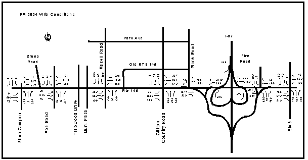 |
| Exhibit 2-65. Route 146 Network Volumes - PM With Conditions |