|
Introduction - Page 1 of 1 |
ID# C3IN001 |
Introduction
 Printable
Overview, Introduction, and Getting Started
Printable
Overview, Introduction, and Getting Started
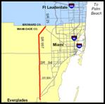
Krome Avenue
(SR 997) is
one of the westernmost roadways in the Miami urban area, separating the developed
portion of Miami from the Everglades, as shown in the map of
Exhibit 3-1. There are no access controls that
would give it any of the characteristics of a freeway. Traffic volumes are
moderate; and congestion is not a major problem, except at a few critical
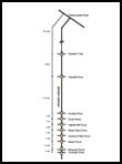
intersections with important east-west arterials. A schematic overview of
the entire route is presented in
Exhibit 3-2.
This route has all of the
characteristics of a two lane rural highway at the north end. It becomes
increasingly urbanized (still retaining the two-lane configuration) and is
clearly a signalized arterial at the south end of the study section. There
are several intersections, both signalized and unsignalized, that require
attention and analysis to determine what, if any, modifications should be
made. Some of the intersections have unusual features that will be explored
to create a better understanding of the application of the HCM.
Discussion:
 Consider the
situation described above and review the sketches and location map showing
the street system. What steps would you need to go through to conduct a
useful and relevant study of the Krome Avenue route identified in
Exhibit 3-1? After you have listed these steps, continue to
the next page to learn how we can apply the methods of the Highway Capacity
Manual to address these issues and provide assistance to decision makers on
how to improve this road facility.
Consider the
situation described above and review the sketches and location map showing
the street system. What steps would you need to go through to conduct a
useful and relevant study of the Krome Avenue route identified in
Exhibit 3-1? After you have listed these steps, continue to
the next page to learn how we can apply the methods of the Highway Capacity
Manual to address these issues and provide assistance to decision makers on
how to improve this road facility.
[
Back ]
to Overview [
Continue
] to Getting Started