The intersection of U.S. 95 with Styner Avenue-Lauder
Avenue is currently stop-controlled, and is the focus of a controversy over
whether a signal ought to be installed.
To understand the context in which our analyses will be
conducted, it is important to note that U.S. 95 is the primary north-south state highway in Idaho,
carrying between 15,000 and 23,000 vehicles per day through the city of
Moscow, a community of 21,000 persons located in north Idaho. The city is home to the University of Idaho, the state's land grant
university with a student population of nearly 11,000.
Traffic on this section of
U.S. 95 has been increasing at the rate of nearly
two percent per year over the past decade. As it enters the city from the south, U.S. 95 transitions from
a two-lane highway to an urban arterial with both signal and stop-sign
control. Much of the land use to the south is farming, with some
industrial, commercial, and residential development encroaching into these
less developed sections of the area.
The area to the east of
U.S. 95 in the southern part of the
city is primarily residential, particularly along Styner Avenue and
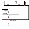
Palouse River Drive. Click the link
to Exhibit 1-1 on the left to see this section of the city's highway system.
In the southern part of the city,
U.S. 95 transitions from a
two-lane highway to a four-lane arterial. Two of the intersections
(State Highway 8 and Sweet Avenue) are controlled by traffic signals while
three of the intersections (Taylor Avenue, Styner Avenue, and Palouse River
Drive) are controlled by stop signs. There
are also a number of driveway access points along the arterial. Click on Exhibit
1-2 to see an overview sketch of the U.S. 95 corridor and Exhibit 1-3 to see
an aerial view of U.S. 95.
The intersections of
U.S.
95/State Highway 8 (see Exhibit 1-4) and
U.S. 95/Sweet Avenue
(see Exhibit 1-5) are signal controlled,
operating fully-actuated, with no coordination between them. The three unsignalized intersections are located at Taylor Avenue/U.S. 95, Styner-Lauder Avenue/U.S.
95 (see Exhibit 1-6) and Palouse River Drive/U.S. 95.
Click the links to the
left to view aerial photographs of these intersections.