|
Problem 4 - Page 1 of 6 |
ID# C204001 |
Problem 4: Clifton Country Road
 Problem 4 Printable Version
The intersection of
Clifton Country Road and Route 146 (Intersection
D) is the most complex, busiest, largest, and most complex in the network.
Exhibit 2-36 shows an aerial photograph of the site. (North is toward the
top.)
|
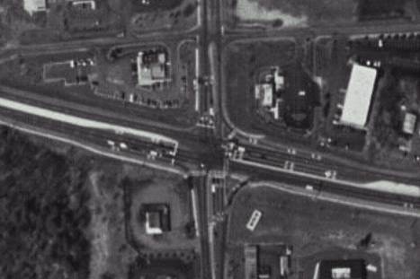
Exhibit 2-36. Clifton Country Road Aerial Photograph |
The main question at
this intersection will be: are geometric changes and/or adjustments in
signal timing needed to accommodate the site-generated traffic? Since a
lot of the site-generated traffic will be going to and from I-87, the
signal timings will have to change, dictated by the actuated controller. But geometric changes might be needed as
well. In the process of answering these questions, we can use this
intersection to illustrate a number of analysis issues.
|
 |
|
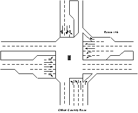
Exhibit 2-37.
Clifton Country Road and Route 146 intersection configuration |
As you can see in
Exhibit 2-37, the intersection’s eastbound approach is five lanes wide
(left, triple through, and signalized right). The westbound approach is
also five lanes wide (double left, double through, and free right). The
southbound approach has three lanes (left, left/through, and
right/through) while the northbound approach has four (double left,
through, and free right). The eastbound left-turn bay is about 150 feet
long. The westbound left-turn
bay is about 400 feet long so it can accommodate heavy volumes coming from
I-87. On the southbound
approach, there’s space to store about 10 cars per lane to the upstream intersection with Old Route 146. On the northbound approach,
about 20 cars can be stored per lane prior to the first side road
intersection.
[ Back
] [Continue ] to Base Case Condition